
Bus route 62 in Liverpool links “Linacre Lane” and “Heathfield Road”. The return journey starts at “Smithdown Place” (50 m from “Heathfield Road”).
Which way bus 62 runs
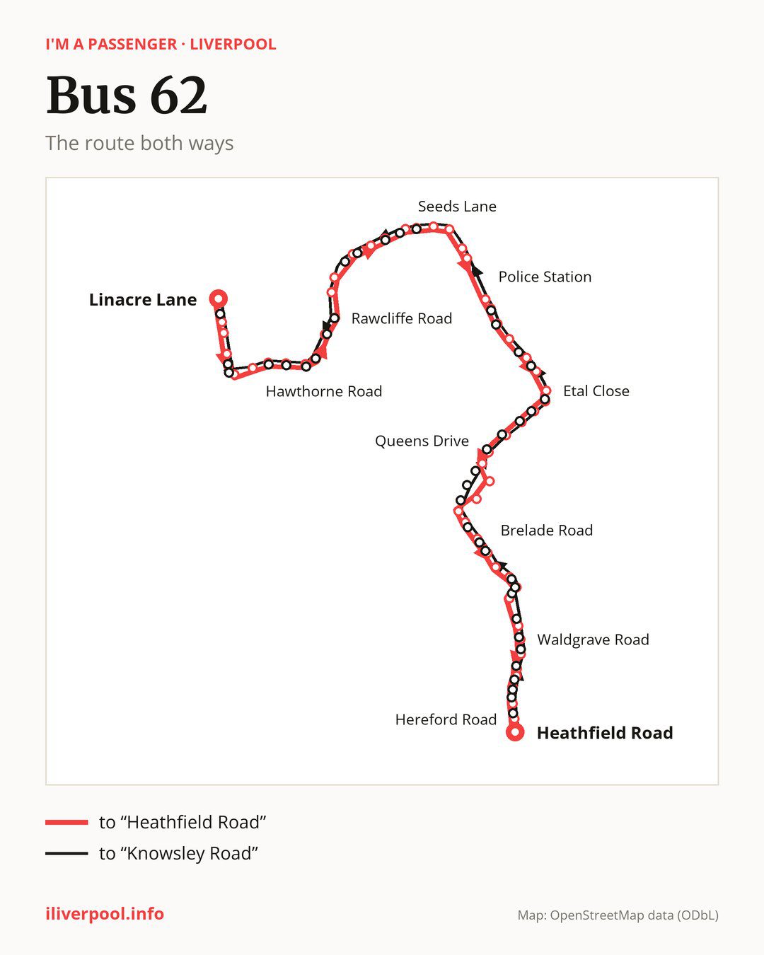
From “Linacre Lane” to “Heathfield Road”: 53 stops. On the way: “Marsh Lane”, “Bootle Strand Interchange”, “Park Street”, “Trinity Road”, “Stanley Road”, “Hawthorne Road”, “Southport Road”, “Stuart Road”, “Rice Lane”, “York Street”. Then “Clock Tower Drive”, “Rawcliffe Road”, “Rice Lane Interchange”, “Orrell Park Interchange”, “Warbreck Moor”, “Goodacre Road”, “Greenwich Road”, “Seeds Lane”, “Barlows Lane”, “Fazakerley Interchange”. Then “Aintree University Hospital”, “Police Station”, “Long Lane”, “West Derby Cemetery”, “Storrington Avenue”, “Carr Lane East”, “Etal Close”, “Kerman Close”, “Meadow Lane”, “Marldon Road”. Then “Almonds Green”, “Liddell Road”, “Queens Drive”, “Three Butt Lane”, “Bankfield Road”, “Santon Avenue”, “Rockbank Road”, “Tynwald Hill”, “Brelade Road”, “Bolan Street”. Then “Greenfield Road”, “Prescot Road”, “Maddocks Street”, “Binns Road”, “Waldgrave Road”, “Crossley Drive”, “Old Mill Lane”, “Wellstead Road”, “Childwall Road”, “Woolton Road”. Before “Heathfield Road”: “Hereford Road”.
On the way back the bus takes a different route, from “Smithdown Place” to “Linacre Lane” (55 stops). Only in this direction does it call at “Beverley Road”, “Fir Lane”, “Hunters Lane”, “Mill Lane”, “Valencia Road”, “Deverell Road”, “Birch Grove”, “Edge Lane Drive”, “Davidson Road”, “Tesco”, “Booth Street”, “Sark Road”, “Woburn Hill”, “Sutton Street”, “Lisburn Lane”, “Delamain Road”, “Adshead Road”, “Altham Road”, “Lorenzo Drive”, “Lewisham Road”, “Stalisfield Avenue”, “Wingrave Way”, “Carr Lane”, “Utting Avenue East”, “East Lancashire Road”, “Ternhall Road”, “Seventh Avenue”, “Higher Lane”, “Bradville Road”, “Solar Road”, “Grace Road”, “Fazakerley Road”, “Cavendish Drive”, “Denbigh Road”, “Astor Street”, “Hill Crest”, “Balliol Road East”, “Balliol Road”, “Merton Road” and “North Park Court”. Only in the direction of “Heathfield Road” does it call at, among others, “Marsh Lane”, “Park Street”, “Trinity Road”, “Stanley Road”, “Southport Road” and “Stuart Road”. For the way back, board nearby: “Marsh Lane” → “North Park Court” (150 m), “Park Street” → “Merton Road” (200 m), “Trinity Road” → “Merton Road” (50 m) and “Stanley Road” → “Balliol Road” (100 m). Towards “Heathfield Road”, board nearby: “Beverley Road” → “Hereford Road” (100 m), “Fir Lane” → “Woolton Road” (100 m), “Hunters Lane” → “Childwall Road” (50 m) and “Mill Lane” → “Wellstead Road” (100 m).
Left column runs down, right column runs up. Filled stops are served both ways, dashed ones only one way: 40 towards “Heathfield Road” and 42 the other way. Tap a stop to see its name.
Other routes along the way
Shared sections with other routes: between “York Street” and “Fazakerley Interchange” it shares the road with routes 20 and 21; between “Santon Avenue” and “Greenfield Road” it shares the road with routes 68, 68A and 68B; between “York Street” and “Warbreck Moor” it shares the road with route 345.
Connections by stop, in route order:
- “Linacre Lane”: buses 52, 58, 61, 61A, 61B, 217 and 217A
- “Marsh Lane” (only towards “Heathfield Road”): buses 52, 58, 60, 61, 61A, 61B, 81, 81A, 135, 217 and 217A
- “Bootle Strand Interchange”: buses 52, 58, 60, 61, 61A, 61B, 81, 81A, 135, 217 and 217A
- “Park Street” (only towards “Heathfield Road”): buses 52, 58, 60, 81, 81A, 135, 217 and 217A
- “Trinity Road” (only towards “Heathfield Road”): buses 52, 58, 60, 81, 81A, 135, 217 and 217A
- “Stanley Road” (only towards “Heathfield Road”): buses 52, 58, 81, 81A and 135
- “Hawthorne Road”: buses 52, 58, 60, 81, 81A and 135
- “Southport Road” (only towards “Heathfield Road”): buses 58, 60, 81, 81A and 135
- “Stuart Road” (only towards “Heathfield Road”): buses 60, 81, 81A and 135
- “Rice Lane” (only towards “Heathfield Road”): buses 60, 81 and 81A
- “York Street” (only towards “Heathfield Road”): buses 60, 81 and 81A
- “Clock Tower Drive” (only towards “Heathfield Road”): bus 214
- “Rawcliffe Road” (only towards “Heathfield Road”): bus 214
- “Rice Lane Interchange”: buses 214, 217 and 217A
- “Orrell Park Interchange”: buses 61, 61A, 61B, 121, 135, 214, 217 and 217A
- “Warbreck Moor” (only towards “Heathfield Road”): buses 61, 61A, 61B, 121, 135, 214, 217 and 217A
- “Goodacre Road”: buses 61, 61A, 61B, 121, 135, 214, 217 and 217A
- “Greenwich Road” (only towards “Heathfield Road”): buses 135, 217 and 217A
- “Seeds Lane” (only towards “Heathfield Road”): buses 135, 214, 217 and 217A
- “Barlows Lane” (only towards “Heathfield Road”): buses 135, 214, 217 and 217A
- “Fazakerley Interchange”: buses 17A, 102, 214, 217 and 217A
- “Aintree University Hospital”: buses 17, 17A, 102, 121, 214, 215, 217 and 217A
- “Police Station”: buses 17, 17A and 102
- “Long Lane” (only towards “Heathfield Road”): buses 17, 17A, 19 and 102
- “West Derby Cemetery”: buses 14, 14A, 17, 17A, 19, 102 and 698
- “Storrington Avenue” (only towards “Heathfield Road”): buses 14, 14A, 102, 215 and 698
- “Carr Lane East” (only towards “Heathfield Road”): bus 215
- “Etal Close”: buses 121, 214 and 215
- “Kerman Close” (only towards “Heathfield Road”): buses 121, 214 and 215
- “Meadow Lane” (only towards “Heathfield Road”): buses 121, 214 and 215
- “Marldon Road” (only towards “Heathfield Road”): bus 121
- “Almonds Green” (only towards “Heathfield Road”): buses 61, 61A, 61B and 121
- “Liddell Road” (only towards “Heathfield Road”): buses 60, 81 and 81A
- “Queens Drive”: buses 60, 81 and 81A
- “Three Butt Lane” (only towards “Heathfield Road”): buses 15, 60, 81 and 81A
- “Bankfield Road” (only towards “Heathfield Road”): bus 15
- “Santon Avenue”: bus 15
- “Rockbank Road” (only towards “Heathfield Road”): bus 15
- “Brelade Road” (only towards “Heathfield Road”): buses 10A and 10B
- “Bolan Street”: buses 10A, 10B and 60
- “Greenfield Road” (only towards “Heathfield Road”): buses 10A, 10B, 60, 61 and 61B
- “Prescot Road” (only towards “Heathfield Road”): buses 7, 10A, 10B, 60, 61 and 61B
- “Maddocks Street” (only towards “Heathfield Road”): buses 7, 60, 61 and 61B
- “Binns Road” (only towards “Heathfield Road”): buses 7 and 204
- “Waldgrave Road” (only towards “Heathfield Road”): bus 204
- “Crossley Drive” (only towards “Heathfield Road”): bus 204
- Stops from “Old Mill Lane” to “Childwall Road” (only towards “Heathfield Road”): buses 78, 79 and 204
- “Woolton Road” (only towards “Heathfield Road”): bus 78
- “Hereford Road” (only towards “Heathfield Road”): buses 78 and 174
- “Heathfield Road”: buses 75, 76, 80, 80A, 86, 86A, 174 and 201
- “Smithdown Place”: buses 75, 76, 80, 80A, 86, 86A, 174 and 201
- “Beverley Road” (only towards “Linacre Lane”): bus 78
- Stops from “Fir Lane” to “Mill Lane” (only towards “Linacre Lane”): buses 78, 79 and 204
- “Valencia Road” (only towards “Linacre Lane”): buses 79 and 204
- “Deverell Road” (only towards “Linacre Lane”): bus 204
- “Birch Grove” (only towards “Linacre Lane”): bus 204
- “Edge Lane Drive” (only towards “Linacre Lane”): buses 7, 60 and 204
- “Davidson Road” (only towards “Linacre Lane”): buses 7, 10A, 10B, 60, 61 and 61B
- “Tesco” (only towards “Linacre Lane”): buses 7, 10A, 10B, 60, 61 and 61B
- “Booth Street” (only towards “Linacre Lane”): buses 10A, 10B, 60, 61 and 61B
- “Lisburn Lane” (only towards “Linacre Lane”): bus 15
- “Delamain Road” (only towards “Linacre Lane”): buses 15, 60, 81 and 81A
- “Adshead Road” (only towards “Linacre Lane”): buses 60, 81 and 81A
- “Altham Road” (only towards “Linacre Lane”): buses 60, 61, 61A, 61B, 81, 81A and 121
- “Lorenzo Drive” (only towards “Linacre Lane”): buses 61, 61A, 61B and 121
- “Lewisham Road” (only towards “Linacre Lane”): bus 121
- “Stalisfield Avenue” (only towards “Linacre Lane”): buses 121, 214 and 215
- “Wingrave Way” (only towards “Linacre Lane”): buses 121, 214 and 215
- “Carr Lane” (only towards “Linacre Lane”): buses 14, 14A, 102 and 215
- “Utting Avenue East” (only towards “Linacre Lane”): buses 14, 14A, 102 and 698
- “East Lancashire Road” (only towards “Linacre Lane”): buses 17, 17A, 19 and 102
- “Ternhall Road” (only towards “Linacre Lane”): buses 17, 17A, 19 and 102
- “Seventh Avenue” (only towards “Linacre Lane”): buses 135, 214, 217 and 217A
- “Higher Lane” (only towards “Linacre Lane”): buses 135, 214, 217 and 217A
- “Bradville Road” (only towards “Linacre Lane”): buses 135, 217 and 217A
- “Solar Road” (only towards “Linacre Lane”): buses 61, 61A, 61B, 121, 135, 214, 217 and 217A
- “Grace Road” (only towards “Linacre Lane”): buses 61, 61A, 61B, 121, 135, 214, 217 and 217A
- “Fazakerley Road” (only towards “Linacre Lane”): bus 214
- “Cavendish Drive” (only towards “Linacre Lane”): bus 214
- Stops from “Denbigh Road” to “Hill Crest” (only towards “Linacre Lane”): buses 60, 81 and 81A
- “Balliol Road East” (only towards “Linacre Lane”): buses 58, 60, 81, 81A and 135
- “Balliol Road” (only towards “Linacre Lane”): buses 52, 58, 60, 81, 81A, 135, 217 and 217A
- “Merton Road” (only towards “Linacre Lane”): buses 52, 58, 60, 81, 81A, 135, 217 and 217A
- “North Park Court” (only towards “Linacre Lane”): buses 52, 58, 60, 61, 61A, 61B, 81, 81A, 135, 217 and 217A
- “Knowsley Road”: buses 52, 58, 61, 61A, 61B, 217 and 217A
Pages for these routes: bus 10A, bus 10B, bus 14, bus 14A, bus 15, bus 17, bus 17A, bus 19, bus 20, bus 21, bus 52, bus 58, bus 60, bus 61, bus 61A, bus 61B, bus 68, bus 68A, bus 68B, bus 75, bus 76, bus 78, bus 79, bus 80, bus 80A, bus 81, bus 81A, bus 86, bus 86A, bus 102, bus 121, bus 135, bus 174, bus 201, bus 204, bus 215, bus 345, bus 698.
Passes and concessions
Our page “How to pay for public transport in Liverpool” describes tickets, passes and concessions, including any differences between modes of transport.
Questions about bus 62
Where does bus 62 start its return journey?
At “Smithdown Place” (50 m from “Heathfield Road”).
Where can I change from bus 62 to another bus route?
Most routes stop at “Marsh Lane” (only towards “Heathfield Road”; 52, 58, 60, 61, 61A, 61B, 81, 81A, 135, 217 and 217A) and “Bootle Strand Interchange” (52, 58, 60, 61, 61A, 61B, 81, 81A, 135, 217 and 217A). All other stops with connections are listed above.
Checked on 1 October 2026. Source of the route and stops: Merseytravel.